
Making Wine Maps

I’m not quite sure that the old saying applies to wine maps, the danger here being that it might not be too exciting except to the hardest of the hard core wine map geeks! Also, I can imagine some of our competitors would probably not like you to see how theirs are made.
There are four major ways that wine maps are made: survey style specifications, satellite imagery, commune specifications, and vineyard plots. We present this information in the name of transparency and in the spirit of in vino veritas, as maps, like wine are only as good what they’re made from and how they're made.
Survey Style Specifications
This is the way that the United States as well as Italy do their maps. The outline of each region is specified in text corresponding to locations on a map. The locations can be literally reference points, like mountain peaks and buildings, as well as linear references like roads, rivers, property and contour lines.The example here is from the Rogue Valley in Oregon.
§9.132 Rogue Valley.
The boundaries are as follows:
(1) Beginning at the point of intersection of Interstate 5 and the Josephine County/Douglas County line approximately 20 miles north of Grants Pass, the boundary proceeds southerly and southwesterly along U.S. Interstate 5 to and including the town of Wolf Creek; (2) Then westerly and southerly out of the town of Wolf Creek along the Southern Pacific Railway Line to and including the town of Hugo; (3) Then southwesterly along the secondary, hard surface road known as Hugo Road to the point where the Hugo Road crosses Jumpoff Joe Creek; (4) Then westerly and down stream along Jumpoff Joe Creek to the intersection of Jumpoff Joe Creek and the Rogue River; (5) Then northwesterly and down stream along the Rogue River to the first point where the Wild and Scenic Rogue River designated area touches the easterly boundary of the Siskiyou National Forest just south of Galice; (6) Then in a generally southwesterly direction (with many diversions) along the easterly border of the Siskiyou National Forest to the 42 degree 0 minute latitude line; (7) . . . (25) Then westerly along the north lines of T34S, R1E; T34S, R2W; T34S, R3W; T34S, R4W; and T34S, R5W, to the northwest corner of T34S, R5W; (26) Then northerly along the west line of T33S, R5W, to the Josephine County/Douglas County line; (27) Then westerly along the Josephine County/Douglas County line to U.S. Interstate 5, the point of beginning.

Satellite Imagery
The maps of Argentina, Chile, and New Zealand are constructed this way. All of these countries define virtually all of their wine regions by political boundaries. Some wine map makers follow this literally, and I've seen more than one wine map of New Zealand that is indistinguishable from a political map.
To make them more relevant to the wine world, we use satellite imagery to determine the vineyards and potential vineyard areas within each region. Here's an example of how one region, Maule in Chile, is constructed. Looking at the map, it becomes evident that if we just went by the official specification, a large part of Maule would be in the Andes!

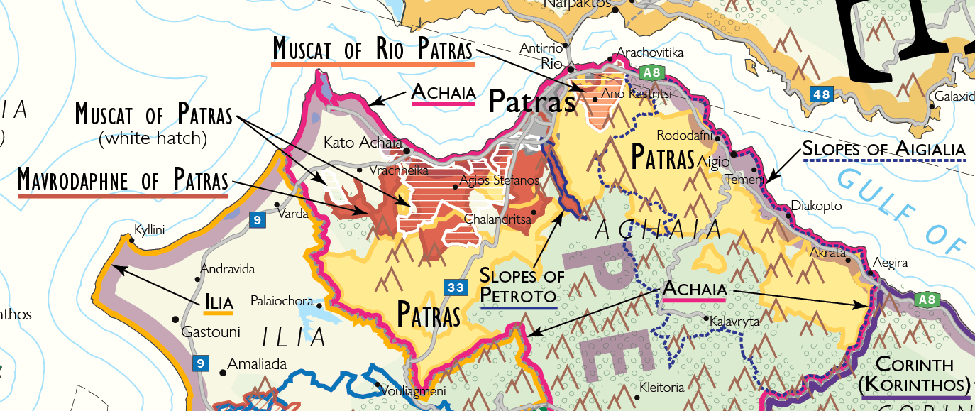
Commune Specifications
France, Spain, and Greece all use this method for most of their regions. They are made up of agglomerations of communes (communities); the borders of one or many villages combine to make up a wine region.
In this example, you can see how we plot just one of Greece's 153 regions, Patras, in our Wine Map of Greece. In addition to diving into the wine laws, we often look at the other maps available, especially those made by professional organizations in their respective countries. The Greek Ministry of Rural Development and Food (the agency responsible for wine regions) provides this map that is sketched over a map of Greek communities:

At first glance, this looks very good as it uses the communities that were around when Patras PDO was first legally defined in 1971(pre Kapodistrias). But looking at a map provided by The New Wines of Greece, they have a much different idea of Patras' boundaries:

At this point, the only thing to do is to use the original legal text describing the boundaries. Here it is in Greek:

After having the text professionally translated, we have a very good idea of how the region is defined:
The PDO Patras zone covers the following sub-mountainous municipal districts and communities that belong to the Achaia Prefecture:
a) The municipal districts of Aegae, Vella, Monastiri, Oasi, Seliana (Kolokithianika settlement), Sinevro and Chrisabeloi of the Municipality of
b) The municipal districts Dafnes, Koumaris, Kounina, Mavriki, Melissia, Paraskevi, Pteri (settlements of Achladia, Agios Andreas, Selitsa), Selinountas (over the settlement) and Chatzis of the Municipality of Aigio.
c) The municipal districts of Akrata (over the irrigation ditch), Ampelos, Valimi (Lithopetra settlement), Voutsimos, Kalamia, Paralia Platanou and Platanos of the Municipality of Akrata.
d) The municipal districts of Ano Diakopto, Diakopto (Kalivitsa, Kernitsa, Niamata and Lofos settlements), Zachloritika (over the National Highway), Keryneia, Mamousia and Trapeza (over the National Highway) of the Municipality of Diakopto.
e) The municipal districts of Erineos, Damakini, Neos Erineos (over the railway line), Salmeniko and Arravonitsa of the Municipality of Erineos.
f) The municipal districts of Agios Konstantinos, Alsos, Verino, Gkrekas, Grigoris, Dimitropoulo, Doukaneika, Krini, Lakka, Longos (over the National Highway), Mageiras, Mirovrisi, Nerantzies, Rododafni (over the National Highway), Selianitika (over the National Highway) and Toumpa of the Municipality of Simpolitia.
g) The municipal district of Plataniotissa of the Municipality of Kalavrita.
h) The municipal district of Elaiochori of the Municipality of Dymi.
i) The municipal districts of Velitses and Michio of the Municipality of Larissos
j) The municipal districts of Elikistra, Moira, Patras (settlements of Ano Sichena, Charadro, Sikossa, Mpalas) and Souli of the Municipality of Patras.
k) The municipal districts of Ano Kastritsi, Argyra, Kato Kstritsi, Pititsa and Sella of the Municipality of Rio.
l) The municipal districts of Agia Varvara, Agia Marina, Drosia (settlements of Agrapidia, Koumperi), Erimanthia, Kalfas, Manesi, Roupakia, Skiadas, Skouras, Spartia (Kiparissi settlement) and Chiona of the Municipality of Tritaia.
m) The municipal districts of Vasiliko, Elliniko, Kritharakia, Mirali, Starochori and Chalandritsa of the Municipality of Farres.
n) The municipal districts of Mazaraki (settlements of Galaneika, Gkaneika, Kato Mazaraki), Mitopoli, Portes, Santomeri, Flokas and Charavgi of the Municipality of Olenia.
o) The settlements of Avrami, Agios Georgios and Mponteika of the Community of
p) The settlement of Ano Mazaraki of the Community of Leontio.
We plot this using the pre Kapodistrias community boundaries:
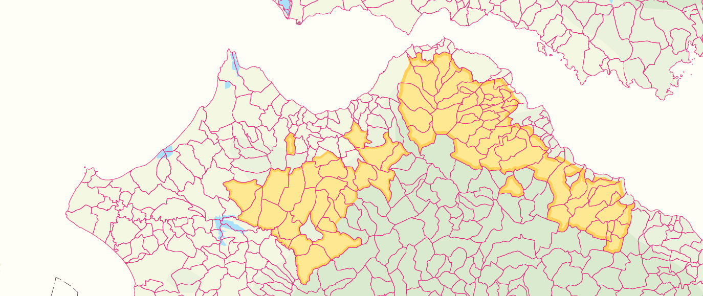
And place the region in the final map:
It's a great deal of work, especially since that's only one of 153 regions.
Vineyard plots
At the scale we work at, most vineyard plots would be just dots on a map, so we don’t usually work at that level of specificity.
However, in Germany, we had no choice but to work with vineyard plots if we wanted a map more specific than just a bunch of blobs. The German wine authority, Deutsches Weininstitut, has developed incredibly detailed vineyard maps, so much of our work was to retain as much detail as possible on a single map of Germany while maintaining legibility or in cartographer’s terms, good generalization.
In some of the detailed maps, however, we were able to show the designated plots like here in Rheingau:

If you've made it to here, I hope that was better than seeing how sausages are made!