


Grande Montagne Sud, Champagne
$50.00
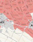
The map of the wine villages of the Grande Montagne Sud, Champagne printed on 115 lb (170 gsm) premium matte paper.
A detailed presentation of the southern slope of the Grande Montagne, it includes the grand cru villages of Louvois, Tours-sur-Marne, Bouzy and Ambonnay, and the premier cru villages of Tauxières-Mutry, Villers-Marmery, Trepail, Billy-le-Grand and Vaudemange.
This map is part of Mapping Champagne, a series of maps by Steve De Long and Charles Curtis MW. It's the first modern update and expansion of the pioneering work of Larmat, which was done in the 1940s.