


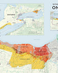
Wine Map of Ontario


NOTE: If you are ordering from Canada, please purchase from Pierre Ferland's Read Between the Wines. Pierre consulted extensively on the project.
Canada's first commercial winery opened on Pelee Island in Ontario in 1866, which is ironically the southernmost region in Canada. The modern era of winemaking in Ontario began in 1975 when Inniskillin was granted the first new winery license since the 1916-27 Prohibition. Today, Ontario boasts over 17,000 acres of vineyards and produces a diverse range of world-class wines.
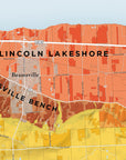
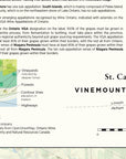
This map shows all of Ontario's VQA (Vintners Quality Alliance) regions. VQA is a regulatory and appellation system which guarantees the high quality and authenticity of origin for Canadian wines. It is similar to European systems such as AOC (Appellation d'origine contrôlée) in France and DOC (Denominazione di origine controllata) in Italy.
The main focus is on the Niagara Peninsula region, which produces the vast majority of Ontario's wines. The map is printed on 115 lb (170 gsm) premium matte paper. It's available in two sizes: our regular 24 x 36 inch (600 x 900 mm) size and the giant 40 x 60 inch (1000 x 1500 mm) size. It's produced using the latest mapping technology, current wine laws and regulations of each region, as well as consultation with wine industry professionals. Since it is printed on demand, it is completely up to date.
Our maps are the choice of industry professionals and are seen in wine shops, tasting rooms and classrooms throughout the world.